| code | County | Region/province | Area | HQ | Outdoor Activities |
| 1 | Mombasa | Coast | 212.5 | Mombasa (City) | Deep sea diving, Skydiving, snorkelling, Beach games, swimming, trekking |
| 2 | Kwale | Coast | 8,270.3 | Kwale | Mwaluganje Elephant Sanctuary (MES) is a community-owned elephant park, a conservation area for elephants and Encephalartos cycads in Kwale County, Kenya.
Location[edit] It is located 45 km southwest of Mombasa and is adjacent to the Shimba Hills National Reserve. The sanctuary was formed in the early 1990s as a cooperative project between the people of the surrounding Mwaluganje community, United States Agency for International Development, and the Born Free Foundation and the Eden Wildlife Trust.[1] Ecotourism[edit] MES is an example of ecotourism, as well as community-based-conservation efforts, both of which are very recent trends in conservation management. In this community-based program, the local people have leased their privately owned property to a community-based trust. The trust manages the sanctuary for the conservation and preservation of the elephants. In addition it is a valuable source of revenue for the local people, re through monies generated by eco-tourism and gate entrance fees. The area is off the Shimba Hills escarpment in Kwale County and is on the migratory route leading to Tsavo East National Reserve.[2] Some of the revenue generating activities include creating paper from elephant dung, bee keeping (honey products)and biofuel |
| 3 | Kilifi | Coast | 12,245.9 | Kilifi | Malindi now falls under Kilifi County as per the administrative changes in the new constitution passed in August 2010. Malindi forms a municipal council with the following thirteen wards: Barani, Ganda/Mkaumoto, Gede, Gede North, Gede South, Kijiwetanga, Madunguni, Malimo, Malindi Central, Malindi North, Maweni, Shella, Watamu Town. All of them are located within Malindi Constituency.[6]
Arabuko sokoke Forest walks • Forest drives • Bird watching • Butterfly watching • Camping • Cycling • picnicking • Running Deep sea diving, Skydiving, snorkelling, Beach games, swimming, trekking, camel treks, dhows, canoeing |
| 4 | Tana River | Coast | 35,375.8 | Hola | The park has several rocky inselbergs, the highest of which are Mansumbi at 488 metres and Kumbulanwa at 450,metres. The park has several seasonal rivers
Pristine wilderness, inselbergs, Tana River with Adamson’s Falls, Grand Falls and Kora rapids, diverse birdlife, George Adamson’s grave and that of his brother Terence and favorite lion, Boy. Game drives, rock climbing, George Adamson’s grave and the annual commemoration of George Adamson on 20th August (he was shot by the Shifta bandits in 1989) fishing in River Tana. The major ethnic groups are the Pokomo, many of whom are farmers, and the Orma and Wardey, who are predominantly nomadic. |
| 5 | Lamu | Coast | 6,497.7 | Lamu | Dodori National Reserve is a protected area located in Lamu East District of Coast Province in Kenya. It was documented in 1976[1] and its 877 km² encompasses an important woodland and forest area that historically supported large populations of wildlife, including elephants, lions, buffaloes, and coastal topi.
The Dodori National Reserve is managed by Kenya Wildlife Service and is part of a larger area that has been recognized globally as an important cultural heritage area and a prized conservation site by international organizations such as the IUCN, Conservation International, World Wildlife Fund, among others. Together with the nearby Kiunga Marine National Reserve, the Dodori National Reserve was named a UNESCO Man and Biosphere Reserve in 1980.[2] References[edit] Jump up ^ |
| 6 | Taita-Taveta | Coast | 17,083.9 | Voi | |
| 7 | Garissa | North Eastern | 45,720.2 | Garissa | |
| 8 | Wajir | North Eastern | 55,840.6 | Wajir | |
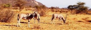
| 9 | Mandera | North Eastern | 25,797.7 | Mandera | Malka Mari National Park is a national park of Kenya, situated along the Daua river on the Kenya-Ethiopia border.[1] It is approximately 1,500 square kilometres (370,000 acres) in size. It is accessible via the Mandera Airport, and is probably the most visited national park in the nation.
The park is mostly semi-arid bushland and scrubby grassland with riparian woodland and along the river. There are plants in the park that are unique to the area.[1] Malka Mari is a IUCN Category II park designated in 1989.[2] |
| 10 | Marsabit | Eastern | 66,923.1 | Marsabit | Despite being a semi-arid region, Marsabit County is endowed with several tourist attractions. These include Marsabit National Park, Lake Paradise, Chalbi desert, Lake Turkana, Desert Museum, Sibiloi National Park, among others.
Sitting on 1,554 square km, Marsabit National Park comprises a forested mountain and three impressive crater lakes that provide a habitat to a huge population of animals such as buffalo, elephants, giraffe, zebra, leopard and lion. The park also hosts numerous species of birds. Marsabit National Park Category: Tourist Attractions in Marsabit County The 1,554sq km Marsabit National Reserve is about 560km north of Nairobi and 263km north of Isiolo in Marsabit County. It comprises densely forested mountain and three crater lakes that are the only permanent surface of water in the region and provide habitat for a variety of birdlife. For more information visit: Marsabit National Park Lake Turkana Category: Tourist Attractions in Marsabit County At Kenya’s far Northern frontier lies one of the natural wonders of the world Lake Turkana. Lake Turkana is a massive inland sea, the largest desert lake in the world (6,405 sq km). This single body of water is over 250 kilometres long- longer than the entire Kenyan coast. For more information visit: Lake Turkana Sibiloi National Park Category: Tourist Attractions in Marsabit County The 1,570sqkm Sibiloi National Park Kenya is on the north east
Sibiloi National Park ern shore of Lake Turkana in Marsabit County, about 800km north of Nairobi. It is one of the world’s greatest treasures as the cradle of humankind. For more information visit: Sibiloi National Park Accommodation Marsabit National Park offers some of the best accommodation in the county. Marsabit Lodge situated within the park is a popular choice for many travellers. Other accommodation options include Ahmed and Abdul camp-sites near the national park, Al-Yusra Hotel and Hotel Abreham both in Moyale. Travellers heading to Marsabit can also find accommodation at the Samburu Intrepids Tented Camp in Archer’s Post, about 200km from Marsabit town. |
| 11 | Isiolo | Eastern | 25,336.1 | Isiolo | |
| 12 | Meru | Eastern | 5,127.1 | Meru | |
| 13 | Tharaka-Nithi | Eastern | 2,409.5 | Chuka | |
| 14 | Embu | Eastern | 2,555.9 | Embu | Mwea National Reserve
From Wikipedia, the free encyclopedia Mwea National Reserve SafariCamps com Mwea National Reserve Map Visit Kenya Safari Holiday Adventure SafariGuide com B.png Location of Mwea National Reserve Location Embu County, Kenya Nearest town Siakago Coordinates 0°49′05″S 37°37′19″ECoordinates: 0°49′05″S 37°37′19″E[1] Area 42 km2 (16 sq mi) Established 1976 Governing body Kenya Wildlife Service http://www.kws.org/parks/parks_reserves/MWNR.html The Mwea National Reserve is a nature reserve in Kenya.[2] It is characterized by bushy vegetation and scattered large trees (Acacia species and baobab trees), typical savannah ecosystem. Open grasslands are dominant along the main rivers, with occasional thick undergrowth. Contents [hide] 1 Wildlife 2 Bird watching 3 Camps 4 Other attractions 5 References 6 External links Wildlife[edit] Game species range from African elephants, lesser kudus, Nile crocodiles, giraffes, Grant’s zebras, buffalos, African leopards, common duikers, black-backed jackals, bushbucks, waterbucks, Sykes’ monkeys, warthogs, rock hyraxes, bush pigs, impalas and hartebeests. Striped ground squirrels, genet (animal)s and yellow baboons are also found in Mwea. Bird watching[edit] Renowned for its water birds and waders, over 200 species of birds have been recorded in the reserve. This warranted it being an Important Bird Area (IBA). The reserve is the only protected area in which the globally threatened and Kenya-endemic Hinde’s babbler (Turdoides hindei) is known to occur. Mwea National Reserve also shelters two other rare species; the Pel’s fishing owl (Scotopelia peli) and the white-backed night heron (Gorsachius leuconotus). The Malagasy pond heron (Ardeola idae) is also a common sighting. Camps[edit] The reserve has seven campsites: Mbogo, Silvester, Mavuria, Kyangosi, Hippo-Point, Kanyonga and Githechu. Other attractions[edit] These include game viewing, boat rides at Kamburu dam, hippo sighting at Hippo Point, bird watching and walking (walking circuit). Giraffes in the Mwea National Reserve |
| 15 | Kitui | Eastern | 24,385.1 | Kitui | |
| 16 | Machakos | Eastern | 5,952.9 | Machakos | Ol Donyo Sabuk National Park |
| 17 | Makueni | Eastern | 8,008.9 | Wote | |
| 18 | Nyandarua | Central | 3,107.7 | Ol Kalou | |
| 19 | Nyeri | Central | 2,361.0 | Nyeri | |
| 20 | Kirinyaga | Central | 1,205.4 | Kerugoya / Kutus | |
| 21 | Murang’a | Central | 2,325.8 | Murang’a | |
| 22 | Kiambu | Central | 2,449.2 | Kiambu | |
| 23 | Turkana | Rift Valley | 71,597.8 | Lodwar | |
| 24 | West Pokot | Rift Valley | 8,418.2 | Kapenguria | |
| 25 | Samburu | Rift Valley | 20,182.5 | Maralal | |
| 26 | Trans Nzoia | Rift Valley | 2,469.9 | Kitale | |
| 27 | Uasin Gishu | Rift Valley | 2,955.3 | Eldoret | |
| 28 | Elgeyo-Marakwet | Rift Valley | 3,049.7 | Iten | |
| 29 | Nandi | Rift Valley | 2,884.5 | Kapsabet | |
| 30 | Baringo | Rift Valley | 11,075.3 | Kabarnet | Lake Bogoria
Category: Tourist Attractions in Baringo County Lake Bogoria in Baringo County is a popular tourist attraction site due to its active geyser. The geysers produce stream reach in sulphur compounds, which are believed to be medicinal. In the same area are not – which have been harnessed by the local noted industry.
For more information visit: Lake Bogoria Lake Baringo Category: Tourist Attractions in Baringo County Lake Baringo is, after Lake Turkana, the most northern of the Great Rift Valley lakes of Kenya, with a surface area of about 130 sq km. The lake is fed by two rivers, El Molo and Ol Arabel and has no obvious outlet, despite this it being one of the two freshwater lakes in the Rift Valley in Kenya, the other being Lake Naivasha. It lies off the beaten track in a hot and dusty setting and over 470 species of birds have been recorded there, occasionally including migrating flamingos. For more information visit: Lake Baringo Ruko Conservancy Category: Tourists Attractions in Baringo County Ruko Conservancy is a 19,000-hectare-area to the north and east of Lake Baringo, consisting of bushland and about 10km of shoreline. |
| 31 | Laikipia | Rift Valley | 8,696.1 | Rumuruti | |
| 32 | Nakuru | Rift Valley | 7,509.5 | Nakuru | |
| 33 | Narok | Rift Valley | 17,921.2 | Narok | |
| 34 | Kajiado | Rift Valley | 21,292.7 | Kajiado | |
| 35 | Kericho | Rift Valley | 2,454.5 | Kericho | |
| 36 | Bomet | Rift Valley | 1,997.9 | Bomet | |
| 37 | Kakamega | Western | 3,033.8 | Kakamega | |
| 38 | Vihiga | Western | 531.3 | Vihiga | |
| 39 | Bungoma | Western | 2,206.9 | Bungoma | |
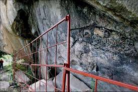
| 40 | Busia | Western | 1,628.4 | Busia | Tourist Attractions in Busia County
Kakapel is a rock site located on a huge rock shelter in the Chelelemuk hills in Teso North sub County, Busia County. The rock art at Kakapel is believed to have been done by the Twa (Abatwa) hunter gatherer group. It has paintings illustrating wild animals, rain-making and initiation symbols. The Kakapel Rock Site was opened to the public in 2007 following rehabilitation by the National Museums of Kenya between 2005-2006. The site is important to Kenya’s prehistory as it is believed the art forms date over 2000 years and may be as much as 4000 years old. Generally, rock art is one of the oldest forms of art in the world. In Africa, rock art is more concentrated in Southern and Northern Africa countries The Samia HillsCategory: Tourist Attractions in Busia CountyThe Samia Hills in Samia Sub County represent the basement complex and consist of acid and sub-acid lavas, tuffs and agglomerates, banded quartzite and iron stones. The Kavirondo series rocksCategory: Tourist Attractions in Busia CountyThe Kavirondo series rocks are developed around Busia, Nambale and Butula while the granites dominate the northern parts of the county. The northern part of the central region features granitic out crops, which is essentially part of the peneplain and is characterized by the presence of large granitic hills such as Amukura and Chelelemuk. The Southern part is covered by a range of hills which run from the north east to the south west culminating at Port Victoria, forming a very conspicuous topographical feature. The southernmost part of the county is covered by the Yala Swamp that that is down warped area associated with the formation of Lake Victoria. |
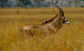
| 41 | Siaya | Nyanza | 2,496.1 | Siaya | Ruma National Park is the only terrestrial park in Nyanza Province. Dubbed the “Last Retreat of the Roan Antelope”, the park protects the only indigenous population of rare roan antelopes within Kenya. At present, the population is on the verge of extinction with individual populations numbering approximately 40. The park was established in 1966 as Lambwe Valley Game Reserve. It was later renamed “Ruma” after one of Kenya’s most powerful wizard, the much feared Gor Mahia who lived around the park (affiliated to Gor Mahia F.C.). The park is located in the vast Lambwe Valley.
Contents [hide] 1 Wildlife 2 Park entry and charges 3 See also 4 References 5 External links |
| 42 | Kisumu | Nyanza | 2,009.5 | Kisumu | |
| 43 | Homa Bay | Nyanza | 3,154.7 | Homa Bay | |
| 44 | Migori | Nyanza | 2,586.4 | Migori | Lakes, Rivers and Waterfalls
Lake Victoria… The presence of the lake in the region has lead to the development of tourism in the area. This is due to the ever increasing number of local and regional and international tourists that visit the region annually. Ruma National Park
Ruma National Park Category: Tourist Attractions in Migori County The 120sq km Ruma National Park is close to the shores of Africa’s largest inland lake, Lake Victoria. It is situated in Lambwe Valley in South Nyanza, 425km from Nairobi, 140km from Kisumu, 10km east of Lake Victoria and south west of Homa Bay. |
| 45 | Kisii | Nyanza | 1,317.9 | Kisii | |
| 46 | Nyamira | Nyanza | 912.5 | Nyamira | |
| 47 | Nairobi | Nairobi | 694.9 | Nairobi (City) |