| Location | Rift Valley |
| Starting Point | Longonot Park Gate |
| Ending point | Longonot Park Gate |
| Walking Duration | 3 hours |
| Prevalent Weather | Hot, dusty and windy. Afternoon showers. |
| Terrain | Very dusty, steep trail |
| Difficulty | Moderate |
| Elevation gain | 600m |
Objective
The goal of this hike is to reach the summit of Mt Longonot (2,780 m above sea level), walk along the crater rim, and return to the park gate.
Trail Overview
Although the trail is relatively short — about 3.1 km to the crater rim and approximately 5 km to the summit — the hike is strenuous. It is made physically demanding by loose scree, dusty soil, and a steep gradient. Most hikers take about half a day to complete it.
This hike is suitable for both solo hikers and groups.
Trail Description
The hike begins at the park gate, located at around 2,150m above sea level. After registration and payment, you start on a fairly flat stretch. On a good day, you may spot zebras, warthogs, and other wildlife grazing as you hike past the campsite where the hike climb begins
The first section is 30-40 minutes of gentle incline. It may feel manageable at first, but it gradually starts to bite as the muscles and lungs adjust to the altitude and pace.
Next come the concrete steps. Here, the gradient increases sharply, and the real effort begins. After climbing the steps, you reach the first rest hut.
From there, you proceed eastward through a light thicket. The trail climbs steadily, becoming steeper as you approach the crater rim. Eventually, you reach the second hut at the rim.
At the Crater Rim
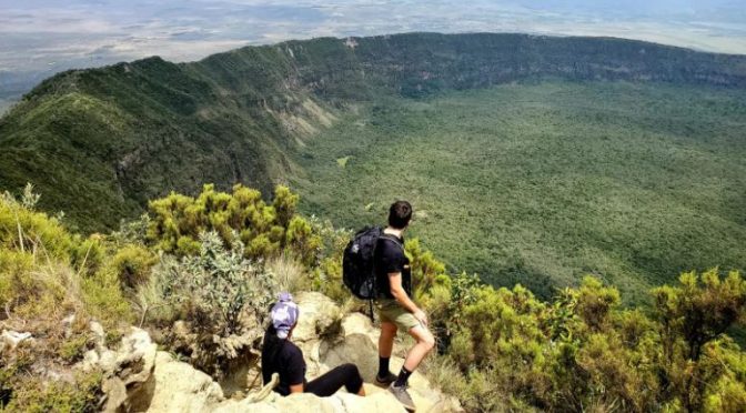
The view at the rim is breathtaking. The vast caldera stretches below you, making it a perfect spot for photos and rest. While it is possible to continue, it’s advisable to pause and regain your energy.
From here you can approach the summit in two ways:
- Clockwise route: about 5.3 km
- Counter-clockwise route: about 1.9 km
Most be chose the counter-clockwise route. Whichever the selection, the full circumference of the crater rim is approximately 7.2 km. The loose soil, steep ascents, and frequent false peaks can be frustrating and physically demanding.
Summit Experience
Once you get to the Ngamia summit, you are rewarded with sweeping views of the Great Rift Valley. On clear days, you can even see vehicles winding along the escarpment far below.
From here, you can either descend the same way you came or complete the full crater-rim circuit before heading back down.
Optional Extensions
If the main hike feels too short (it can take as little as 3 hours for fast hikers), consider these additional challenges:
1. Secondary Crater
Near the rim hut, there is a signposted detour to the secondary crater. The trail is visible at first but quickly fades. You’ll need to bushwhack through rough terrain with deep ravines, making this a more adventurous option.
2. Crater Floor
Walking anticlockwise from the rim hut, look out for a sign marking the descent to the crater floor. The drop is about half a kilometre down cliffs.
At the bottom, you can explore unique features such as hot vents and unusual rock formations.
Park Fees
Mt. Longonot National Park is managed by the Kenya Wildlife Service (KWS), and standard park fees apply.
- Adults (Non-residents): $20
- Residents and children: Charges vary (confirm current rates with KWS)
Guiding
A guide is not necessary for the main trail, as it is clearly marked. However, if you plan to explore off the main routes, a guide may be useful.
Local guides are available at the gate and may offer services, including walking sticks for hire. Decide based on your needs and experience.
Getting There
By Car
Drive to Mai Mahiu town, about 70 km from Nairobi. From there, head 9 km towards Naivasha until you see the Mt Longonot National Park signpost. Turn off and drive 4 km to the gate.
By Public Transport
- Take a matatu from Nyamakima (Nairobi) to Mai Mahiu (approx. KES 150).
- From Mai Mahiu, board another matatu heading to Naivasha.
- Alight at the Mt. Longonot turnoff.
- Walk 4 km to the park gate.
Alternatively, you can hire a taxi, a seven-seater matatu, or take a boda boda from Mai Mahiu to the gate.
Final Notes
Mt Longonot may be short, but it is a tough hike. Start early, carry enough water, and pace yourself. The views and sense of accomplishment at the summit make every step worth it.