| Location | Maĩ Mahiũ/Longonot |
| Starting Point | Mai Mahiu – Longonot road |
| Ending point | Mai Mahiu – Longonot road |
| Walking Duration | 5 hours |
| Terrain | Grassy uphill and motorable road |
| Difficulty | Easy |
| Elevation gain | 650m over 3km |
Few people will tell you the name of the hill near Mai Mahiu in Nakuru County. This is because Kijabe Hill lost its name when Kijabe School relocated from the foot of that hill to its current location in the Eastern Escarpment of the Great Rift Valley. Kijabe Hill rises quietly north of Mai Mahiu—Maĩ Mahiu, if you want to get it right. It means “hot water,” and around here, vowels matter. Change them, and you could be saying something entirely different.
From the road, the hill does not look dramatic. Not like Longonot. Not like Suswa. It sits there, almost modest. But do not be fooled. Kijabe does not shout. It tests.
The plan is simple. Climb to the top. Cross over. Loop back to the Mai Mahiu–Naivasha road. On paper, it is a short hike—just over 3 kilometres to the summit. For a beginner, that translates to three, maybe four hours of steady effort.
Simple, yes. Easy, no.
The Beginning: A Gentle Lie
The hike starts about 9 kilometres from Mai Mahiu, roughly halfway to Longonot town. At 2,010 metres above sea level, the air already feels a little thinner, a little cleaner.
You set off heading north. The trail rises immediately, but it is kind at first, straight and predictable. You fall into rhythm and out of breath. Soon, the railway line appears. It slices across your path like a quiet checkpoint. This is where you pause. Turn back. Look at how far you have come. Sip water. Pretend you are still fresh.
The Hill Tightens Its Grip
Beyond the railway line, the trail bends northeast. The gradient sharpens. The path narrows. Gullies appear—deep, sudden, and unforgiving. They are carved by erosion and restless earth. This is not a place to improvise. You follow the guide. Closely.
Then come the thorns.
At first, they brush against you. Then they grab. They scratch. They insist. Your ankles and shins take the brunt of it.
It is mildly infuriating. And oddly helpful.
You become so busy dodging branches and lifting your feet just right that you forget to complain about the climb. Time slips. The hill plays tricks on your mind.
The False Promise
Eventually, the terrain changes again. Rocks take over. The slope steepens.
And then you see it—the “top.”
It looks close. Just beyond that rocky outcrop.
You push harder. This is it. Almost there.
But Kijabe is not done with you.
You reach it… and realise it is not the summit.
Just a false peak.
A quiet lesson in humility.
The Real Summit
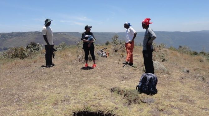
Beyond the deception, the climb continues to 2,659 metres above sea level and there you are. No fanfare. No signboard. Just wind, sky, and the satisfaction of having earned your place there.
You sit, breathe and let your legs rest for the journey back. A snack or lunch can be had here depending on when you started. Unfortunately, the top of Kijabe Hill is bare without shelter and the vagaries of the weather seem to know it. July will freeze you. March will toss you around. The sun will not be gentle. But you will not care.
Because the view opens up like a reward.
Where Kenya Unfolds
From the top, all the trails you dream of connect.
To the south, Mount Suswa spreads wide and ancient, while Longonot guards the West. East is Elephant Hill, the dreaded, quiet and watchful. And beyond, the eastern escarpment stretches—Kinare, Kiharu, Nathan’s, William’s Hill—layer upon layer of ridges fading into the horizon.
Then your eyes drop.
Below, patches of green stand out against dry grasslands. IDP camps. Small, resilient pockets of life. Trees growing where they are needed most.
Up here, the world feels both vast and very close.
The Way Down
What took hours going up takes about two hours coming down. Gravity is now your friend. You descend eastward. Cross the railway line again. The rhythm is easier now. Lighter. Eventually, you reach the abandoned old Kijabe town. Quiet. Still. Almost forgotten.
From there, you walk about an hour along a motorable road heading west. It is a gentle finish. Soon, the highway appears. You are back where it all began—just four kilometres from your starting point, though it feels like a different journey entirely.
Getting There
Personal: Drive your vehicle to Mai Mahiu town and leave it there. It is safer. But if you have a driver, you can drive it to the starting point.
Public Means: Take a Matatu to Mai Mahiu from the Old-Nation Roundabout.
What You Need
- A local guide (not optional—necessary)
- Guide fee
- Respect for the land and the community
Because Kijabe is not just a hill you climb. It is a hill that quietly climbs into you.