| Location | Mai Mahiu/Longonot |
| Starting Point | Mai Mahiu – Longonot road |
| Ending point | Magina |
| Walking Duration | 9-10 hours |
| Terrain | Grass, human tracks and motorable road |
| Difficulty | Moderate |
| Elevation gain | 650m |
The objective of the Kijabe Hill – Nathan Hill hike is to traverse the section between Mai Mahiu and Magina.
The hike takes you up Kijabe Hill (2,400 m a.s.l.), across the Old Kijabe saddle, and finally up Nathan Hill. It is a rewarding route that combines elevation gain, scenic views, and varied terrain.
Trail Overview
This hike combines two trails: Kijabe Hill and Nathan Hill.
The starting point is about 9 km from Mai Mahiu, roughly halfway to Longonot town. The trail begins at an altitude of 2,010 m a.s.l.
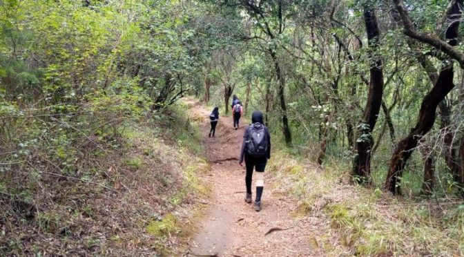
You start by heading north along a gentle incline. The first hour is quiet and reflective as hikers settle into their pace.
At the railway line, turn right and continue northeast toward the summit of Kijabe Hill at 2,659 m a.s.l.
This section covers about 3.2 km and takes 3 to 4 hours.
Kijabe Hill Summit
At the summit, take a short rest.
Enjoy the sweeping views of the surrounding landscape. From here, you can also spot the IDP camp below—a reminder of the area’s history.
Descent and Lunch Stop
From the summit, descend eastwards for about an hour.
You will find a good lunch spot under large euphorbia trees. The shade and quiet make it ideal for a break.
Old Kijabe Town
After lunch, continue east. Cross the railway line and head toward Old Kijabe town.
The town feels quiet and almost abandoned today. However, its small shops can still be useful for refilling water.
Forest and Mission Section
Beyond Old Kijabe, the trail flattens for about an hour.
Some sections follow the road, but most of the route passes through forest. You will walk through thick vegetation and open clearings that make great picnic spots.
As you approach Kijabe Mission, the trail gradually climbs again. You enter the mission area through back paths near the hospital.
Wathing’ito Bridge to Nathan Hill
After leaving Kijabe town at Wathing’ito Bridge, the terrain changes.
The eastern escarpment becomes steeper. The trail passes through local settlements, with many sharp turns that can feel confusing.
The final stretch is the toughest. Nathan Hill is a steep climb of about 200 metres. It looks manageable at first, but it feels much longer as you ascend.
Final Stretch and Reward
The climb up Nathan Hill is demanding. Keep a steady pace.
If the weather is clear, you will be rewarded with a spectacular sunset over the escarpment.
From here, descend toward Magina. A well-earned treat awaits—goat soup and mutura.
Fees and Logistics
- Guide fee: Applicable
- Guiding: Recommended
- Local community: Engage respectfully and support local services where possible
Related posts:
 Kijabe Hill Hiking Trail
 Hiking the Aberdare mountain range, Kenya
 Ngong Hills Hiking Trail
 Karura Forest Hiking Trails
Powered by YARPP.